Wednesday, November 8, 2017

three passes trek journal - part 4


Day 6: Pangboche to Dingboche, side trek to Nangkar Tsang

Sleep didn’t come easy to me the night before. Even the afternoon I planned to use for a long nap was spent staring at the ceiling. Still, I refused to acknowledge that I was already showing symptoms of AMS. I assumed I was just overthinking things, hence the lack of sleep.

The trail from Pangboche was cutting through the old floodplain of the Dudh Kosi river, with a very gradual ascent that I never felt like I was gaining elevation. Dingboche is at an altitude of 4410m, which meant climbing more than 400m. But the only time I remember feeling exhausted because of walking on a steep trail was after crossing the river. And it didn’t even last very long.

It took me less than two hours to reach Dingboche. I easily found the teahouse where Dierk and I were supposed to meet but he wasn’t there. The guy who I assumed to be the son of the owners, gave me a note. It was from Dierk and it said that he decided to leave for Chukkung that morning. I didn’t want to make a decision at that moment if I should stay or go so I opted to have my lunch even though it was still too early.

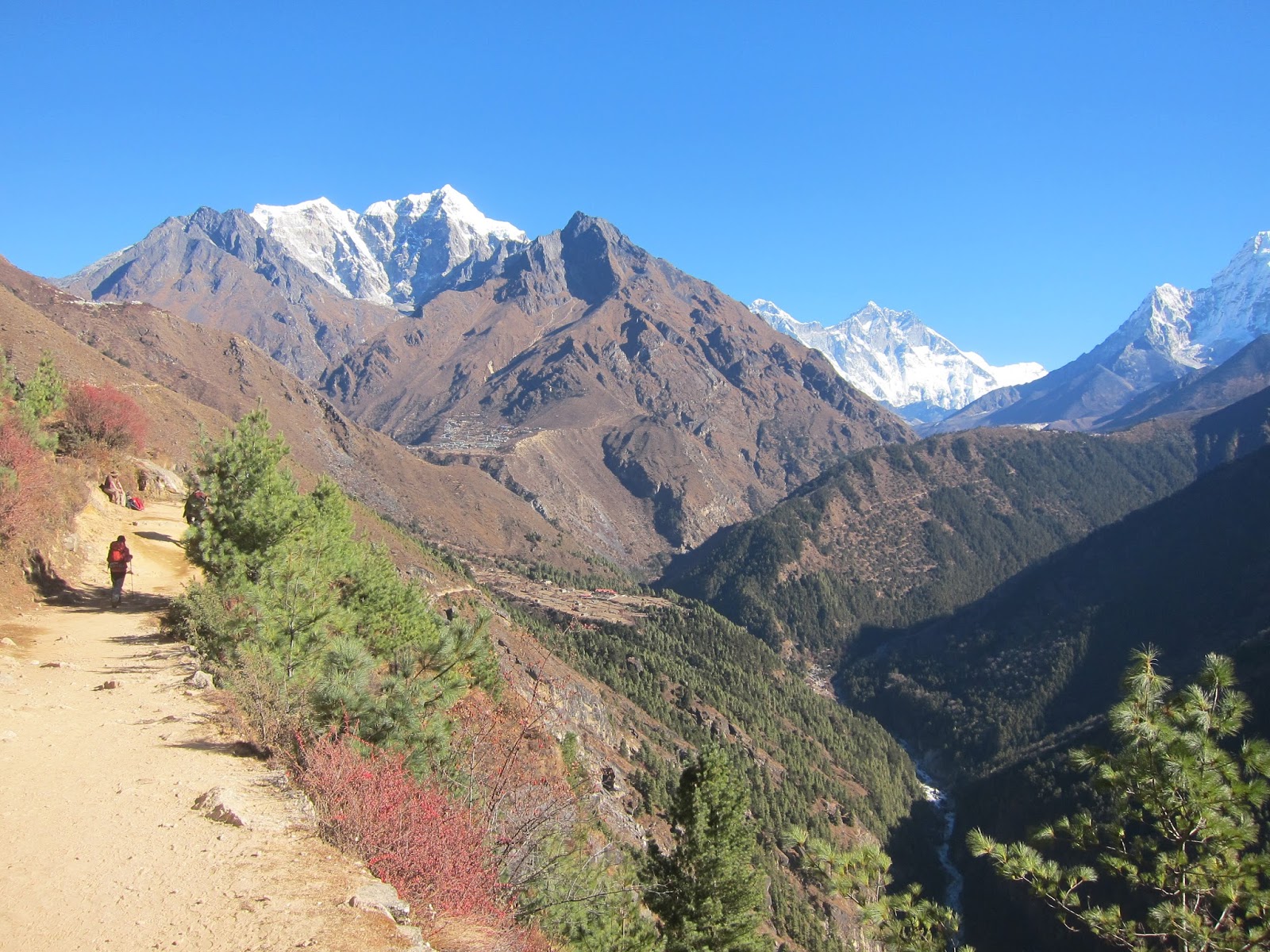
Going up Nangkar Tsang.

Chukkung is less than three hours’ walk from Dingboche. Even if I lingered for an extended siesta, I had enough time in the afternoon to get there. But it is also 300m higher and in terms of acclimatization, proceeding would be a wrong move. Nangkar Tsang is also in the Lonely Planet list of detours. So I opted to stay. And besides, the old woman running the guesthouse seemed very kind.

After a quick rest, I went up to Nangkar Tsang, the hill behind the village. The map I had said it was 5600+m. If I could make it there, it would have been the highest I had ever been. But the people at the guesthouse said it was only about 5100m. Bummer. But it didn’t deter me.

The first part of the climb wasn’t steep. I reached a low ridge with chortens and prayer flags in no time. From there, I had a full view of the village, which was also situated on an old floodplain. The land is parceled with walls. Some have buildings, but most are empty. They’re probably cultivated during the season and it was already post-harvest time.

I continued going up. It was disheartening seeing everyone else already on their way down. I looked behind me for some encouragement but couldn’t see anyone. I looked at my phone and realized it was only half past noon, although people going the opposite direction made it feel like it was already late in the day.


The village of Dingboche. If you could see the orange tents, the one in front of it was the guesthouse I stayed at.

The trail was winding on a steep incline, making lots of switchbacks. I got impatient sticking to it and chose to go straight up, trail or no trail. The trail vanished among a jumble of boulders. The pole with prayer flags attached to it signaled where I needed to go. I found a group of young people when I reached the pole. But farther, I could still see higher peaks. I looked for a way to get there but was told by a guy that we were at a dead end. I glanced past him and saw the ridge has gone too narrow with a sharp drop on both sides. I moved back and found a comfortable spot to enjoy the view. To my left is Chola Tsho and the village of Dragnag, where I would be treading the following week. To my left is Ama Dablam, which looked like something else viewed from that angle. I sat there for about an hour doing nothing else. But actually, I was waiting for everyone to leave so I could have a moment up there on my own. When I heard someone said they’d wait for sunset, I stood up and left. 


Day 7: Dingboche to Chukkung, side trek to Chukkung Ri

No one else came to the guesthouse the previous day and for the first time on this trek, I was the lone guest. So when I went to the dining hall for breakfast, the woman asked me to dine at their kitchen. I didn’t mind it though. It was such a waste of precious fuel heating a large room for just one person.

The kitchen was just starting to heat up. I asked for some muesli with hot milk. I was prepared to receive a measly breakfast but the bowl given to me was so full that she couldn’t put enough milk in it. So instead, she gave me a mug of milk and said that if I needed more, there were still some in the kettle. When you’ve been on a trek where you were made to feel like people want to squeeze every penny out of you, generous acts become strange and at the same time heart-warming.

I didn’t leave the guesthouse well after 9am. Chukkung was only three hours away as I was told. And like the previous day, the trail was only gradually rising that I didn’t feel the 300m increase in altitude. The only challenging part was when I had to go up and down little hills of boulders that didn’t seem to have an ending. And there was a little stream to cross before getting to the village, but it was deeper than my boots could handle. There were planks of wood across the water but their surface was covered with ice so using them was out of the question. I waited for other people to cross to see where they step foot but they all had a pair of trekking poles which made balancing less difficult for them. I took my pole out and started the slow, nervous crossing. There was a guy leaning on a huge rock at the other side of the stream, which made me feel a bit better. If in case I slip and fall, someone could help me. I kept my head bowed down the whole time, carefully choosing the rocks on which to step on. I made it without any incident and when I raised my head, there was no sign of the guy. The thought of me needing any help probably never crossed his mind.


A little hill in Chukkung.

The first guesthouse in Chukkung didn’t feel inviting. The next seemed okay but looked too big that the dining area may get so busy. And besides, I saw the young couples ahead of me went in there and I didn’t feel like being near couples. The third was locked. I knew there were at least four guesthouses so I kept walking towards the end of the village. Even though Chukkung is small, I didn’t feel like going back so when I found the guesthouse, I entered its gate. There were two buildings, the other one looking more like a small annex. I noticed men hanging out in the sun in front of the smaller building and asked if I could get a room. One of them stood up and told me to wait while he gets the key. I followed him but I stopped when I realized that they were drinking. In the middle of the day. It didn’t feel right. But instead of walking away, I just stood there until the man came back. He showed me my room which was located in the annex and it was so sunny, it made me stay.

When I came out of my room, the men weren’t there anymore. I went to the dining hall which was on the second floor of the main building. I took a seat on a sunny spot and ordered daal bhat for lunch. The men I saw earlier arrived and one of them took the table next to mine. He started chatting with me but I was a little apprehensive. He must have sensed my uneasiness so he went on explaining that they were just having one bottle of beer, trying to kill time. It turned out that Mann, the guy talking to me was a guide/coordinator for people who were doing the same trek and also climbing some peaks. The other guys were their porters who were already getting bored because one of their clients took another acclimatization day before climbing Island Peak. When Mann learned that I was trekking on my own, he suggested that I go with his client Brian on crossing the pass the next day. He then went on telling me that Brian is just crossing the three passes; he was also climbing three 6000+m peaks. All in a span of three weeks. Mann added that he was currently the fastest to climb Island Peak among their clients. I knew that I would be too slow for him so I told Mann that I was planning to spend an extra day in Chukkung to see Island Peak Base Camp. Which was true anyway.

In the afternoon, I set out to go up Chukkung Ri. At 5550m, it would be a 700+m ascent from the village. There was also another peak at an elevation of 5800m but it’s less popular. I had some trouble finding the route. I knew I needed to cross the river but couldn’t find a bridge. I searched for it downstream but got no luck. Fortunately, I found a man who walked on the shallowest part of the river. I traced his steps and successfully reached the other side.


The trail that leads to Chukkung Ri.

There was no definite trail from the river. The man just pointed me to where Chukkung Ri is. I could either follow the paths going straight up or those almost parallel ones which were slowly ascending, separated only by lines of dwarf shrubs. I might have chosen the easier path but every step I took was taxing. It wasn’t AMS, I was sure of that. I ate so much daal bhat for lunch I felt so heavy and I was having a hard time breathing. Daal bhat is said to give you “24-hour power” but in my case, the daal bhat decided to hibernate in my stomach and stole all my power. In the end, I only reached a ridge way below my target. From there, I could see the trail to Chukkung Ri. I felt there was no way I could get there so I settled on a defeat. The view was good enough though. And I had the place all to myself.


Day 8: side trek to Island Peak Base Camp

When I woke up, I decided that I would stay another day in Chukkung, even if it meant not having someone to cross Kongma La with. Why worry about tomorrow when I could enjoy today?

I found Mann in the dining hall, smiling at me. It turned out, his client decided to have a rest day which meant we would be crossing the pass on the same day. I could not escape his generosity. But the thing is that it was only Mann making the offer. What if it was not okay for Brian? That was what’s bothering me.

I set off for the base camp. Mann gave me some directions but after crossing a tiny stream, I was already unsure where to go. Good thing I saw a few people walking a little ahead of me. There’s nowhere else to go in that route except the base camp so I just followed them. The whole time we were walking on a hodgepodge of semi-loose rocks which based on what I observed from Nangkar Tsang were a confluence of glaciers that had long melted and were now actively eroded by glacial fed streams. (I may be wrong though.)

After crossing the glacier, I emerged into another valley. The stream had some ice cover but it didn’t stop a group of yaks from hanging around the area. I caught up with the people I was following and confirmed that they were also going to the base camp. They were going a bit too slow for me though so I went ahead. When I encountered a junction, I opted to take a higher trail rather than cross the stream. Upon reaching the lower bank of Imja Tsho (lake), I took out my map and confirmed that I was on the right track. But I had a sudden change of mind. I wanted to take the longer trail, leading to the Amphu Labsta Base Camp which was on the opposite side of Imja Tsho. So instead of turning left, I turned right.
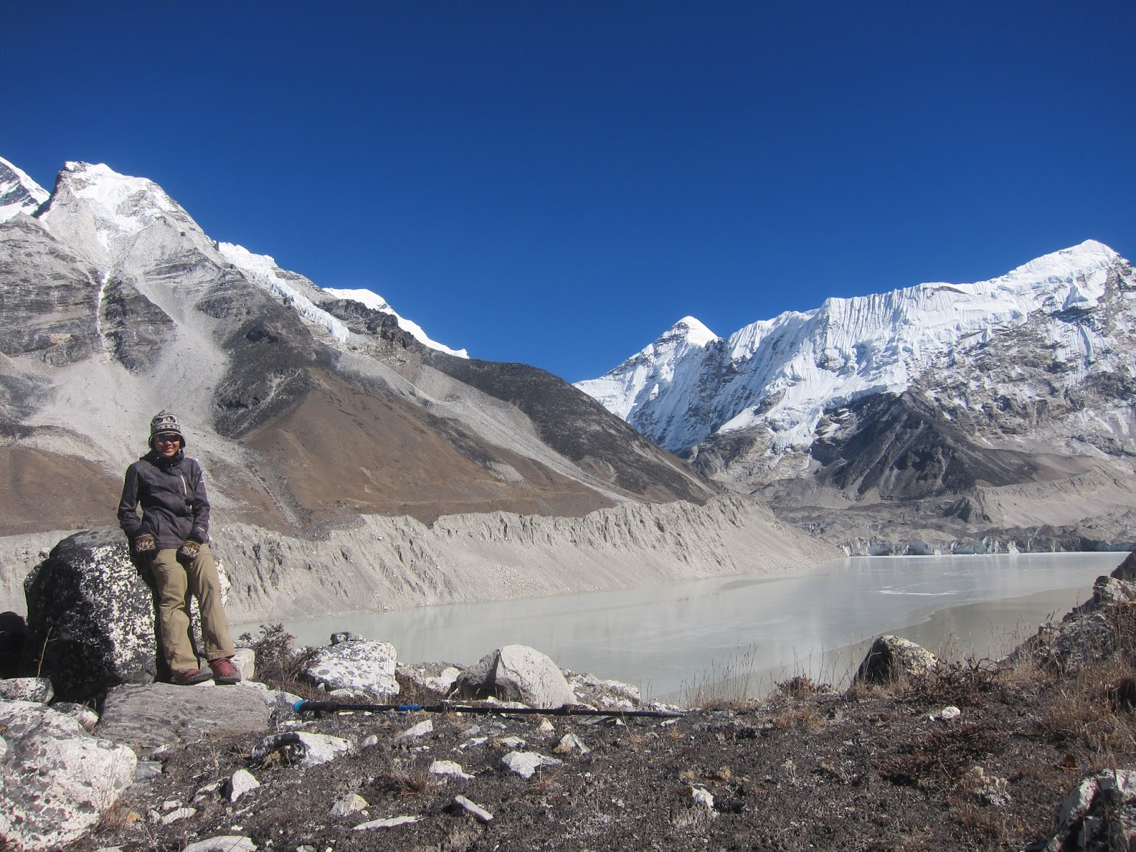
Imja Tsho and I.

It was a surprise to see an excavator (backhoe for my fellow Pinoys) parked near the lake. I also saw a group of men working on some sort of installation and bridge across the stream running from the lake. I read somewhere that the government of Nepal along with UNDP had this project of draining Imja Tsho. Being fed by a glacier which is continuously melting, this lake is one of the fastest-growing in Nepal. This could lead to the lake water breaching its banks causing flash flood which could adversely affect mountain villages. Those men may be part of that project.

The only way for me to get to the other side was through the bridge. I could retrace my way back to the riverbed but it was too far. So I approached the men, half-expecting that they would stop me. I said Namaste and some of them acknowledged my presence but no one seemed to care that I was there. So I just quietly crossed the bridge and went my way.

The walk I took actually wasn’t that interesting. Imja Tsho with its grey colored water wasn’t exactly stunning. My goal that day was to walk as far as I could. I walked past the other guys again, whom I found idling by the edge of the lake. I wasn’t even halfway towards the other end of the lake when I started feeling jittery. No, it wasn’t the men I saw earlier that was causing me worry. I couldn’t stop myself from thinking of a yeti suddenly showing itself, abducting me and taking me to god-knows-where. I don’t even know how it looks like. And getting face to face with a yeti has about the same probability with me stumbling upon the love of my life in that place. Still, it caused me the base camp and I grudgingly retreated.


The view on my way back to Chukkung.

When I reached the guesthouse, I saw Mann sitting with a guy who I assumed was Brian. He was busy writing, most likely a journal. A big book was in front of him. At least we had something in common. I still wasn’t determined going with him though. The guy paid premium for trekking and climbing guides and porters and I would be having some sort of free lunch. Somehow, it didn’t feel right for me.

Before I went to bed that night, I pre-ordered my breakfast. When asked what time I wanted the food served, I wasn’t able to give an answer right away. By chance, Mann was standing beside me and he told the guy to have it ready the same time as Brian’s. And so the morrow’s been decided.

Monday, November 6, 2017

three passes trek journal - part 3


Day 4 - Namche Bazaar to Pangboche


My fourth day doing the Three Passes Trek was the day I made up my mind regarding my itinerary. That is, I wouldn’t have any.


After having breakfast and packing my bag, I went back to the dining area to pay my bill. There I found the guide who offered to adopt me and his team, ready to leave. He told me they would be staying in Tengboche, in case wanted to go with them. Thinking they’d be walking faster than me, I told him I’d find them. My bill was a little over 3000NPR. I gave 4000, but the staff didn’t have enough change so he just gave me back my 1000. It wasn’t that much money but I was still amazed with the contrast from my previous experience.


The 'road' to Everest.
 It seemed like every trekking groups in Namche that day agreed on leaving at the exact same time. I was walking with a herd of people; not much how I imagined spending my day. I tried to walk faster to escape the crowd but just a few steps and I was already panting. And then I remembered the one kilogram of yak cheese I bought the day before. I convinced myself that the weight would be all worth it. Was it? I wasn’t sure except that my backpack was a lot heavier. So I stayed within the pack and fused with its comfortable rhythm.


The woman walking to my right started chatting with me. She expressed her fondness of people like me, adventuring on my own in the Himalayas. She’d been to Nepal 16 times, a number of times alone but most of the time with her husband, who was then trailing behind us. Now, that was a very impressive number. Despite her age, she said she would still find a way to come back and trek in the mountains. She inspired me to do the same. And if I could do even half that, I would have lived a good life.


It was very cold when we left Namche so we were all bundled up when we left. But by then, the sun has gone above the mountains. And the lack of clouds gave the sun full power. We stopped to take some layers off. They decided to take a short rest so I bid them goodbye and went ahead. By then, the crowd has magically thinned out. I could see a few people both way ahead and behind me, but where everyone else had gone was puzzling.


I noticed only then that the trail I was sauntering on was more like a paved road, which could accommodate cars, even trucks. Only that there were none of those in that place. Farther ahead, I came across a man who was sitting serenely in the middle of the ‘road.’ I stopped to read what was written on the nearby signboards and learned that the man is Pasang Lama Sherpa, who was responsible for the improvement and maintenance of the trail in the Khumjung area. It said that he doesn’t get any funds from the government and was relying only on donations to accomplish his endeavor. Such an inspiring man.


Soon, the ‘road’ ended and I found myself walking on a trail lined with some kind of short trees on both sides, whose upper branches meet and make a canopy. Many of those trees have leaves which looked like thick, green hair. It felt like walking in a fairy tale scene. I did like it a lot although not having sweeping views was the trade-off.


Tengboche monastery.
The trail progressively seemed less well-kept compared to the one I was taking in the early morning. I was probably out of Mr. Sherpa’s jurisdiction then. It was also gradually descending, which was not a good thing if you’re on your way up. Add to that the smell of a freshly baked cinnamon bread permeating the air surrounding me. I walked for some time with the whiff torturing my rumbling stomach and making me slobber like crazy. I later found the culprit; a guy walking in front of me who must have stashed a great deal of that bread in his backpack. I wanted to despise him but I understood his action. Thankfully he took a detour to a teahouse before crossing the bridge. I went ahead, grateful that the source of my suffering was then behind me. I only needed to endure the two-hour steep ascent to the village of Tengboche.


It was a hot and dusty climb and the only thing I could see was the other mountain across the gorge. There was no epic scenery to make up for the toil. Although it was still noon, I was ready to call it a day. And then I saw chortens and people and finally Tengboche, straddling in a broad ridge. I was aiming for the set of teahouses at the far end of the village, but my feet couldn’t walk straight to it but instead brought me to a muddy trail, out of the village. Not that I regretted my feet’s decision. Because a few minutes later, I found Rivendell. Legolas wasn’t there but I could gaze all I want at beautiful Ama Dablam while having plates of dal bhaat.


I could have spent the night in that teahouse but I made a passive decision of walking farther. Kind of a wrong move. Sometime later, after crossing a bridge and the trail started going up, I felt a pain on my lower right chest. At first, it was more like a discomfort but it became unbearable as I continued walking. An old man passed me by and must have noticed me hunched, clutching my chest. He was concerned, and offered that I take one of his two guides if ever I needed any help. I thanked him, said that I was fine and continued walking so he would stop worrying. Besides, it was only day 4 and there’s no way I would give up that early. Luckily, the pain went away once the trail levelled.


Funny how I ‘chose’ my guesthouse in Pangboche. Several minutes from the village, I felt a rumbling in my stomach. So I hurried. Once reaching the village, I had my eye out for a place with an outhouse. At the first one that I found, there was a group of young male trekkers. It didn’t feel right. I must have walked several hundred meters more before finding the perfect spot. The only person around was an old man who was busy reading. I quickly unbuckled my backpack, dropped it on the ground and went on with my business. When I went out, I saw a local woman. I smiled at her and asked for a room.


Day 5 - Side trek to Ama Dablam Base Camp


I spent half of the day taking the side trek to Ama Dablam Base Camp. Having accepted the fact that I have a knack for getting lost, I was ready to shut the idea of going there when the guesthouse owner told me that I might have some trouble finding the right trail if I go on my own. But as luck would have it, I met a fellow trekker, Dierk, who offered to go with me. And since he’d been there before, there was little chance we’d lose our way.


I met him the day before, while I was waiting for my dinner to be served, listening to another group of American trekkers lamenting about the recent win of Trump. He approached me while I was busy writing on my journal to ask if I am a trekking guide. Being mistaken for a guide may mean that I looked strong and fit, but he said that it was because I looked like a local.


Getting to the base camp proved to be a bit tricky. At first, we only needed to go down to the river but we diverged from the road too early and even though we could see where we needed to go, the crisscrossing trails before us were either too narrow or too slippery. Once we crossed the bridge, we went up a steep slope which was supposed to be a shortcut, following what seemed to be a derelict trail.  It was mostly worn that I had to use both my hands to climb. It was so steep that the only thing I could see if I look up was the blue sky and there was no telling if the end was nearing or not. I wasn’t going to give up though and a few curses later, the scramble ended and we landed on a wide, flat area.


Ama Dablam as seen on the trail to Tengboche.
The rest of the trek was spent on that gently rolling terrain towards the foot of Ama Dablam. There was not even a single signage telling as to where the base camp was so we only relied on Dierk’s memory of his previous jaunt there. There were trails leading everywhere as the place is used by grazing yaks. Which was kind of incredible because there didn’t seem to be grasses growing on the ground. We went up and down mounds of rocks and dirt until we got a glimpse of brightly colored tents and prayer flags strung on huge boulders.


The place was quiet, with only a few people and yaks roaming the area. We found a guy, and someone who was most likely his guide, sitting comfortably on a camp stool, acclimatizing, as they prepared to attempt reaching the summit in a few days’ time. From afar, I could see a group walking towards the mountain. (About a week later, a magnitude 5.2 earthquake rocked the Everest region. The news said that a Sherpa died from an avalanche in that mountain, while the climber he was with was badly injured.) I was content looking only at Ama Dablam, its prominent peak with ridges radiating from it was a sight to behold.


Ama Dablam Base Camp
Our return journey was without any incident, although the descent on that steep, worn-out trail terrified me a little. Along the way, Dierk and I agreed on climbing Nangkar Tshang together the next day. However, once we reached the teahouse, he felt like walking further that day. I opted to stay to get some rest since I hadn’t been sleeping well for days. So we resolved to meet at a particular teahouse in Dingboche the following morning.


Before leaving, he showed me a photo in his camera – the only photo he took since Lukla. It was of a guy who was about my age and the photo was taken the day before. Dierk told me he first met the guy two years prior, in the Annapurna Circuit. As if the universe conspired, they met again on a different trail. But they were going the opposite direction. Still, it was an extraordinary circumstance. And although trekking in the Himalayas, with its sheer beauty, kind people and daring challenges is a wonderful experience, encounters like that of Dierk and his friend’s is what makes up an epic story. (Which was something I hope I could have as well.)


Wednesday, October 4, 2017

three passes trek journal - part 2

Day 3: Acclimatization hike around Namche

When you rely on your map reading skills in order to get to wherever you want to, not knowing that the map you have does not represent the trails accurately, you are bound to get lost. And that was how I spent the first hour of my hike.

I followed the same trail that I took the day before but when I reached the fork to Thame, I took the path going up. The map I had showed the trail to the Hillary Memorial Stupa going up a ridge. I thought that if I continue going up, I could get there. Somehow, I ended up at the backyard of a guesthouse in the tiny village of Zorak. I saw a man and asked if I was at the right path. He pointed the ridge and said "Up!" and left in a rush with his daughter in tow. I was really hoping he would show me an easier way.

The guesthouse's backyard is actually a wide barren field, parceled with pieces of rocks immaculately piled to create low sturdy walls. I walked and hopped past those walls until two Himalayan tahr or wild goats caught my attention. They were standing on the wall, gazing over the valley below. Their coat glistened against the sunlight. My hair would be put to shame if compared to theirs.

View of Namche Bazaar, Syangboche airstrip and Thamserku from the Hillary Memorial.

I continued walking, looking at the ridge, but there didn't seem to be a trail. I decided to shift to Plan B, which was to go to the stupa via Khunde. I finally saw three women with several yaks from afar and I hurried towards them. But there was a wall that was much higher than I could hop over. It was chest high. I tried looking for a part that was lower but found nothing easier. So I just stood there, waiting for the women to pass before I scramble over the wall. In case I wreck it, it's better to not have any witnesses.

When they passed, I asked if it was the trail to Khunde and they said yes. When I was sure that they wouldn't see nor hear me, I climbed the wall. (And no, I didn't disturb even a tiny piece of rock.) Silly me assumed that where they came from was Khunde so I walked opposite the direction they were taking. Never did it occur to me that my question was a bit vague. Later, I realized that the trail was gradually descending and I was supposed to gain altitude to get to the village. But I kept walking until I reached a junction and recognized my mistake. I had no choice but to go back. Again.

If I didn't refer to my map and just asked anyone at my guesthouse for directions, I would have found out much earlier that the right way starts just a few minutes' walk from where I was staying. But where's the fun in that?

Along the way, I passed by the small village of Syangboche. There was a short runway. I think it also deserves a slot on the most dangerous airports list.

A stupa in memory of Sir Edmund Hillary. In the background is the village of Khumjung.

I reached another junction. Turning left would lead me to Khunde; right, to Khumjung. The trail was a circuitous route so it didn't matter whatever I chose. I planned to visit both the villages anyway. But I wanted to climb to the stupa first thing so I turned left. The two villages are located in a valley, which is above Namche. They are also known as the Green Valley. I wasn't sure why but when I saw it, all the buildings except for the monastery have walls painted with white and roofs of green. That must be it.

The way to the stupa was well-marked, lined with the same make of walls that I climbed earlier in the day. From the monastery, it was a steep ascent. The three stupas, located on a ridge offering sweeping views of the valleys and mountains, were erected in memory of Sir Edmund Hillary, the first non-Nepali to reach the summit of Everest, and his wife and daughter who died on a light plane crash during their visit to Nepal. I spent a good time there gazing at the mountains, still not sure which one was Everest. The valley I would be treading on for the next few days looked endless, lonely and dreary. I was alone the whole time and only saw another trekker on my way down.


At the Tenzing Norgay Memorial. Can you see it? No? Then it must be my sub-par camera.

In the afternoon, I revisited the Tenzing Norgay Memorial where one could have an unobstructed view of the mountains including Ama Dablam, Nuptse, Lhotse and of course, Everest. I was there the day before but couldn't stay long enough because it was too cold and I wasn't wearing enough clothes. I didn't plan on going back but I bumped into the same old man and his guide, again, and they insisted that I be there for sunset. So I did. There was a huge group of Japanese trekkers, young and old and all the in-between. It must be nice to be part of a group like that. Maybe some other time.

Someone told me a few years ago that it's not sunset if the sun just hides behind the mountains. True, not yet. But it's on its way. And sooner, the sun would be low enough, far enough, that most of the blue light has been scattered and removed, leaving only orange and red hues creating a dramatic sunset. The mountains in front of me suddenly beamed with an orange glow. And then slowly, it started to fade; the shadows beneath engulfing the light. And then I saw it, the last of the day's light illuminating the tallest of them all. I was seeing Mt. Everest for the first time.


Part 1 of the Three Passes Trek - Kathmandu to Namche

three passes trek journal - part 1

Day 1: Kathmandu - Lukla - Monjo

I woke up at exactly 4 in the morning. I put on my trekking clothes and made a last minute decision to use only one layer under my windbreaker; a decision I would regret later in the day. The phone in my room rang. It was Saput, the owner of the guesthouse I was staying at, checking if I was already awake. He told me that the car would be arriving in about 10 minutes but there's no need for me to hurry. I said I just have to put a little more stuff in my backpack and I will be set to leave.

Downstairs, I left all the things I wouldn't be needing for the trek. Saput escorted me to the car and wished me a safe trip and reminded me to send him a message once I land in Lukla. He knew how anxious I felt about taking that flight. No matter how much he assured me that it's as safe as any other flights, I couldn't help but be paranoid. Lukla wouldn't be dubbed as one of the world's most dangerous airports for nothing.

We reached the airport a few minutes past 5. I thought I would be rushing to the check-in counter but the entrance was still locked. There were only a few people - trekkers - loitering outside the building. I stood there and watched more people arrive in trickle - trekkers, porters, guides, and their gargantuan duffel bags. And then people poured and I realized that the building has opened. I had no choice but to go at the end of the line. That was half an hour after I got there. I should have queued earlier.

I looked for the counter of Simrik Airlines and queued for check-in. But no staff could be seen. We stood there while all the passengers of other airlines do their business. My flight was scheduled at 6:20am. In any other cases, we all would have missed our flight.

Aboard the plane. We were all (not) excited.

Finally, there was movement in our line. When it was my turn, I was asked to stand on the scale. I lost a little weight despite spending a week in Pokhara and Kathmandu not doing anything but eat and read and sleep. My backpack was at 13.3kg and there was no drinking water in it. I was still holding a few stuff in a paper bag. 15kg wouldn't be a problem, right? I was glad I didn't bring my Shantaram book.

Amazingly, we boarded our 15-seater plane on time. The flight attendant gave us a few candies and cotton balls. Odd. I think it was to plug our ears because the engine was too loud. I wasn't sure. The plane taxied on the runway, preparing for take off. I closed my eyes and clutched the armrest. The plane accelerated and I felt it leave the ground. I opened my eyes and saw how beautiful the morning was. The super moon was low on the horizon. The mountains were bathe with the soft orange glow of the early morning sun. The valley was enveloped with a thick mist. It could be the perfect last sunrise of my life. But it wasn't. The flight wasn't as bad as I expected it to be.

We left the valley and flew north among the mountains. At some point, the plane was flying really close to the slope that if someone was there, I could spy on what they're doing. And then I saw the runway. We landed a few minutes later and collected our backpacks. Everyone was with a group, or a guide. Some people were met by their porters outside the terminal building. I felt a bit sad. Why was I trekking alone again? Ah, that's because I decided that I would do the trek just 3 days prior. I had stopped responding to people sending me messages at the Trekking Partners website a month ago and by that time, people already had made plans.

I walked following the throng of people. I was cold but for some reasons, didn't take out another layer from my backpack. I found myself at the fenced-off end of the runway. A plane was about to take off. I stopped and watched among with a few other trekkers. The plane just gained enough speed before reaching the other end, which is a cliff. It seemed to dip a little before soaring. The return flight looked more daunting.

Lukla airport in the early morning. See the end of the runway?

It was still very early so I stopped at the first teahouse that I saw, waiting for the sun to warm the air even just a bit. The milk tea cost 80 NPR. That was the price at the trailhead. As I sipped my tea, I fervently wished that I wouldn't run out of money before completing the trek.

Half an hour passed and I knew I must go even though the sun was still not high enough. I had my arms crossed across my chest while I walk, trying to fight the chill. A trekker on his way to the airport was laughing as he shouted at me. "This is warm! Up there is cold!" I smiled at him and went ahead, trying as fast as I can to reach the spot where the sun is shining.

The popular evening stopover on the first day is Phakding. Even with my sluggish pace, I reached the village in less than three hours. I put my backpack on top of a bench made with rock slabs and took it off. I looked at my map to check how far the next village was. It was too early to call it a day. The old man and his guide whom I had been walking with in quiet some time that morning saw me and stopped for a moment to chat. They told me they're pushing to Monjo and in terms of acclimatization, it is a better option. Monjo is about the same elevation as Lukla while Phakding is about a couple of hundred meters lower.

It took me another hour and a half to reach Monjo. I found a cluster of teahouses but they didn't feel sunny enough. I walked farther, going up stairs crossing the village, until there were no more buildings. And I had no choice but to go all the way back. I chose the teahouse with the most colorful flower garden.

Lukla's version of Starbucks.

Once inside my room, I made a cocoon of my sleeping bag and fell asleep. It wasn't a very tiring day, the trail was relatively gentle but I was having trouble sleeping for the past nights. I was woken by the noise of more trekkers coming in.

I spent the rest of the afternoon and early evening at the dining hall. All the trekkers in there were in a group. I sat there remembering the conversation I had with a local while having lunch. She told me about the trekker who fell off the trail to Pangboche. Apparently, he took some sort of shortcut on a narrow trail, lost his balance and fell to the river. It happened several days ago but his body hasn't been found yet. I had goosebumps while she was telling me the story. If it happened to him, why wouldn't it to me? I tried to shrug off the idea. It was the first day. I should be thinking of the great adventure ahead.


Day 2: Monjo - Namche

The thing about not trekking with a group was that I had complete control of my time. I missed my Tsum Valley trekking friends but not the stress they gave me all mornings when they just wanted to leave early and I couldn't despite waking up way ahead of everyone else because I couldn't establish an efficient way of packing my stuff. That morning, I woke up, had breakfast and then went back to bed. I was cold and the warmth my sleeping bag offers was tough to resist.

Everyone else has left when I went out of my room. It was a mere 3.5-hour walk to Namche but with a net elevation gain of almost 600 meters. The trail started out easy, just following the river. And then I saw the "Everest movie" bridge. There was actually two of them but the lower one is not of use anymore because the trail leading to it has been damaged beyond repair. Seeing them felt surreal. Like, I was in the movie and it was all make-believe. But it was all real, because the fear I had with crossing hanging bridges felt very real. And the bridge was really high. Everest could be spotted while crossing the bridge. I didn't have time for that though. All I wanted was to get to the other end as fast as I could. But I still was at the mercy of people walking in front of me.

Crossing the Everest movie bridge.

From the bridge, it was a steep walk up. A relentless uphill. The trail was busy with both people and yak porters, going up and down. The rule when coming across those animals is to stay at the mountain side of the trail. That's one thing I would never forget again. I learned my lesson the hard way on my previous trek. So I stuck to the mountainside, even when I was alone on the trail. But that morning, one yak packed with oversized duffel bags on its side decided to be a human for a moment. I could see it coming towards my direction but wasn't able to act quick enough. The yak came too fast and the bag it was carrying struck my right chest. I lost my balance and fell to the ground. Fearing of getting trampled by more yaks, I got up quickly and walked as if nothing happened. I should still be thankful that the yak wasn't carrying metal fuel tanks.

Two and a half hours after leaving Monjo, I reached the check post before Namche Bazaar. I showed my park ticket to the officer and he told me something I couldn't comprehend. I apologized and then he laughed saying that he thought I was a Nepali. That would be the first of the many times it happened during that trek.

When I entered Namche, it felt like going into a metropolis. Namche is the biggest village in the Everest region. I walked past book and souvenir shops and stores selling all trekking and mountaineering gears one would ever need. There were bars and restaurants. The aroma coming in from the cafes and bakeries was mouthwatering. I even found a salon.


Walking around the village and deciding where to spend two nights was not easy. I reached the western end of the village but had to go back because nothing felt welcoming. And then I saw a guesthouse with a "Sherpa" on its name and went to check it out. The interior was lovely and I saw a photo of a Filipino trekking group on display at the lobby along with other photos of previous guests. The price of the room was 400 NPR. I asked for a 50% discount but the owner was adamant that I pay the full price, arguing that he could earn double from the same room if there were two people. I understood his reason but who were we kidding? The trekking season was closing and he's lucky if he could even fill half the guesthouse's capacity.


Yak porters.

I bid him goodbye and walked aimlessly. When something finally caught my attention, I was told that they weren't accepting guests. By then, I was already tired and hungry and I just wanted to lie down. And then I saw Tashi Delek Guesthouse. (Tashi Delek is roughly the equivalent of Namaste in the Tibetan region of Nepal.) I knew I had to stay there even though I had to climb a long set of stairs from where I was. It turned out to be a good decision because not only did they give me a discount, the room I got was overlooking the whole village and it was a really fine view.

While I didn't have a fix itinerary for the trek, I had this list of the top 10 detours off the Everest trek from Lonely Planet. I wanted to tick off as much of it as I could. The first on the list are the rock paintings just above the village's monastery. I went there but didn't see anything except for the huge boulders with carvings, which were common along the trail.

Namche Bazaar.


In the evening, I had a chat with a guide who gave me some tips for the three passes. And then he offered to 'adopt' me. Considering what happened to me in the morning and the perceived difficulty of the trek I wanted to do, I found it hard to resist. The only drawback was that their schedule was not very flexible.

While waiting for dinner, I was given a big cup of hot black tea. I told the girl that she must be mistaken because I didn't order any. She said it was a free welcome drink and apologized she didn't give it to me sooner. Not exaggerating, but I couldn't believe it. I remembered all the arguments and hostility that resulted from the insanely steep cost of tea during our trek in the Manaslu region. If those guys were there, I'm sure they'd be more floored.


Part 2 of the Three Passes Trek - Acclimatization hike around Namche

Monday, October 2, 2017

a complete guide to the three passes trek

“Once is never enough.”

That’s one of Nepal’s tourism slogan and I could attest to the reality of that statement. The first time that I stepped foot on the Himalayas was in 2014 when I did the Annapurna Circuit trek. (You can read about that adventure here.) Even before completing that trek, I vowed to myself that I will go back to Nepal to see more of its beauty and experience its diverse culture. So in 2016, I set out for another (much longer) adventure. I walked the Manaslu Circuit, Tsum Valley, parts of the Annapurna Circuit, Poon Hill and Annapurna Base Camp treks (which I may or may not write about soon) for 32 days. Those combined treks took its toll on me not just physically but also emotionally which made me decide to forgo my initial plan of trekking in the Everest region. But after a week of rest, my feet were feeling the itch and I just couldn’t pass on the experience. So there I was, on the plane to Lukla and now almost a year later, after talking to a friend who wanted to see Everest, I am writing this to help people who are dreaming of walking among the shadows of the tallest mountains in the world.

Mount Everest and Khumbu Glacier as seen from Kala Patthar.

The Trek

Before anything else, you have to decide which trek you want to do. While the Everest Base Camp (EBC) Trek is the most popular and one that needs just about 12 days to complete, there are other options. The Three Passes Trek is much longer and as the name implies, there are three 5000+m high passes which have to be crossed. The Gokyo Lakes Trek could also be done in just two weeks and takes you to the beautiful valley and turquoise waters of these lakes. All these treks start and end in Lukla. The Three Passes route is a circuit. The other two are there-and-back treks but they can be combined by crossing one of the passes.

The Three Passes Trek (the one that I did) takes a minimum of 18 days to complete, including acclimatization days and a few side treks. The three passes from east to west are called Kongma La (5535m), Cho La (5420m) and Renjo La (5360m). (La is the Nepali word for pass.) It can be walked in either clockwise or counter-clockwise direction. Most of the trekking guides I met said that it’s better to do it counter-clockwise, because of the steepness of the assault to the passes walking the other way around. The advantage of doing it clockwise is having to cross the lower passes before Kongma La, which is the tallest and arguably the most difficult.

If you think of the Three Passes trail from Namche Bazaar as a circle, the path to EBC follows the same route for a couple of days to the east, diverging at the village of Dingboche and reconnects with it at Lobuche. From there, it is a day’s walk to the Base Camp. The Gokyo lakes trekking trail departs earlier, taking a north-northwest direction at the middle, meeting the Three Passes trail at the Gokyo Village. If you want to continue to EBC, you have to cross Cho La.


How hard is it?

The most common reaction I get when people find out the I did this trek was ‘WOAH!’ with some sort of disbelief and adoration. I always just sneer, knowing that what they have in mind was far from what I had gone through. Most people associate it to actually climbing Mount Everest. And this is probably one reason why they get daunted with the idea of doing it.

Those two are very different. It’s not even an apple-versus-orange comparison. It’s more like an apple versus a piece of paper. Climbing Everest requires extensive training, mountaineering skills, support team and of course, tons of money. Trekking to the Base Camp or the Three Passes doesn’t involve any special skills. I didn’t have any. The only thing I have is the intense desire to do it. And I could lug a 15-kilogram pack and walk persistently for about six hours a day despite all the discomfort my body feels.

Yak porters. If you come across them on a narrow trail, stay away from the cliff side.

When to go

The best time, which is expected to be the busiest, to go trekking in Nepal is during autumn, which is from September to Mid-November, when the rainy season has passed and the temperature still isn’t that cold. However, I suggest going later in September because the monsoon seems to last longer these days. The second best time is from March to May. This is also the time when mountaineers attempt to reach the summit of Everest. The trail would be very busy but you will get to see all the ‘action’ at the Base Camp. The disadvantage (if I could call it a disadvantage) of trekking during this time, as I was told, was that parts of the trail may be very muddy and slushy because of the melting snow.

I trekked for 23 days in Mid-November to December. I missed the crowd, which is a very good thing. But I found it too cold already, reaching about -18°C at Gorak Shep. Many teahouses also close by December, the owners descending to warmer villages and comes back when trekking season resumes. The same is true for the monsoon season when trekkers are few.


Getting to Nepal

Coming from Manila, the cheapest option to get to Nepal is by flying to Kathmandu via Kuala Lumpur with Air Asia. I've seen round trip promo tickets for as low as 10,000 pesos.

There's no need to apply for a visa prior to your departure. Visa-on-arrival costs 25$ for 15 days, 40$ for 30 days and 100$ for 90 days. If you want, you could extend your stay for up to 5 months for a fee. But staying more than the number of days your visa allows would cost more. You only need a passport-sized photo when getting the visa so don't forget to bring one.


Gokyo Village and Ngozumba Glacier, the longest in Nepal.


Permits and fees

You will need to get two permits. First is the Trekker’s Information Management System or TIMS card. For people who are taking a guide, the fee is 1000NPR per person (1$ = 106NPR in 2016) while for independent trekkers, it is 2000NPR. The second is the park entrance permit costing 3390NPR since those three treks I mentioned are located inside the Sagarmatha National Park.

Both permits could be secured at the Nepal Tourism Board Tourist Information Center in Kathmandu, at the outskirts of Thamel. It’s easy to find using your Google Map. The TIMS requires two copies of passport size photos. And also, take your passport with you when applying. Make sure you have your TIMS card when you go trekking or else you would have to pay a fine. It is also possible to obtain the park entrance permit along the trail, in the village of Monjo. This is what I do since I only had enough money for the TIMS card when I went to their office.


Trekking insurance

When applying for the TIMS card, you will fill-out a form and one of the information you have to write is your insurance policy number. I know someone who got away without having an insurance and probably just jotted down some random numbers and characters. Sure, there’s no way they could check if what you wrote is real or not but that insurance is for you, in case of emergency. Thankfully, nothing bad happened to him during the trek.

You could get cheap insurance but their benefits may not be what you want for a high altitude trek. They also may not be of any use in case of real emergency where you need to be evacuated by a helicopter. This is a serious matter because helicopter rescue costs thousands of dollars. Or your insurance may cover it but not if you’re trekking beyond a certain altitude they would specify, usually only up to 4000m.

I trekked with a relatively cheap insurance and only realized that it doesn’t include helicopter rescue when I was already on my first trek in the Manaslu region. I couldn’t justify to myself spending a hundred dollars’ worth of insurance for a three-week trek so I chose not to upgrade. Note that I am not telling you to scrimp on insurance. I made my decision basing on the knowledge that I already knew what my body could do and that I recognize when I have to give up. I just hoped to heavens that I would be kept away from freak accidents or things I couldn’t control like bad weather or earthquakes.

Helicopter rescue in Gokyo.

On altitude sickness

I've witnessed people who have to be rescued or give up the trek either because of accidents or symptoms of altitude sickness that don’t go away. The more common reason though, based on my experience is the latter.

Altitude or acute mountain sickness (AMS) usually starts when you ascend to ~2500-3000m. Common symptoms include headache, dizziness, irregular sleep, difficulty breathing and lack of appetite. If you have the symptoms, don’t go any farther and spend the night in the nearest village. If the symptoms don’t go away or get severe, immediately descend. Do not take AMS lightly because it could lead to life-threatening situations.

There's no telling who will get altitude sickness but no one is immune from it may you be an athlete or just a regular guy. Some people take a pill called Diamox but I’ve met several who are against this because what the pill does is just to hide the symptoms and not really cure AMS. I’ve never taken that pill. What I did was follow the rule of Climb high, sleep low. It basically says that you must have walked at a higher elevation during the day compared to where you will be spending the night. Another rule is to sleep not more than 300m higher than where you spend your previous night. This may not be possible in some parts of the trek and this is where the acclimatization hikes or side treks become significant.


Gears

If you are like me who is coming from a tropical country, your cold weather gear may be limited to a fleece jacket and a windbreaker or a waterproof jacket. Worry not, because all you’ll be needing could be bought at Thamel. If you don’t know it yet, Thamel is the mecca of not just those who come to Nepal to trek but just about everyone. You will also most likely spend your first and last nights around this area.

It would be a lot cheaper to buy your gears once you get in Nepal instead of shopping say in Manila, for branded outdoor products. Just bear in mind that what you’ll be getting are cheap knock-offs unless you buy them at the brand’s actual store in Thamel. Well, they may be cheap but they would be good enough to last your trek, or another.


Gorak Shep. The black, low peak to the left is Kala Patthar. The trail to EBC is towards the right of the photo.
.
Want and idea of what you should take with you? Here’s a list of what I had during the trek.

Backpack – 55 liters
Trekking boots AND trail running shoes - I liked my boots because they keep my feet warm and dry but there are days when they hurt my feet like hell so I change to trail running shoes
Sleeping bag – Highly recommended. The teahouses provide thick blankets but you may be limited to one when there are lots of trekkers. It could be rented in Thamel for 1$ a day.
Synthetic jacket – I brought two because the first one I used on my other trek was not warm enough. The second one I bought in Thamel. If you want a down jacket, you can buy or rent it in Thamel.
Waterproof jacket / Windbreaker
2 sets of base layers (top and bottom) -  merino wool and capilene. The Uniqlo Heattech line is a good cheaper option
Trekking pants – I have bias over the convertible ones
Socks – 2 pairs of merino wool and 2 pairs of liner socks
Sleeping clothes – pants, socks, base layers and a shirt which I never wore while trekking
Beanie
Warm gloves
Slippers – for if you use the shower
Sunglasses
Baseball cap
Water bottle and 2L bladder
Aquatabs – for water purification. Bottled water is very expensive and not good for the environment.
Trekking pole – better to have two poles
Toiletries, toilet paper, wet wipes
Lip balm and sunscreen
Trail food (about a kilogram of chocolates)
Camera and phone with local SIM
Book, notebook, pen – if it’s not your thing, bring something else you could use to pass the time in the afternoons. If you trek in the shoulder season, you may be the only guest in the teahouse.
Map - pick it up in Thamel. It's very helpful.
First aid kit – paracetamol, loperamide, anti-histamine, band-aids


Do you need a guide?

Trekking in the Sagarmatha National Park does not require you to take a guide or a porter. Actually, there is no need for a guide because the trails are well-marked and if you are not sure which route to take, wait for others. There is a regular traffic of both trekkers, locals and yak/horse porters, unless you are trekking in the dead of winter.

If you want to make your trek richer, then do take a guide with you. If you don’t want to carry a heavy load, hire a porter. This way, you are also giving more jobs to locals. Hiring a guide costs 20-25$ per day while for a porter, it’s about 15$. You don’t have to pay for their food and accommodation. Just make sure that they have gears which are warm enough because you employed them and they are still your responsibility. If you are sure about hiring a guide and/or porter, arrange it in Kathmandu. Either they will be coming with you or you’ll meet them in Lukla. Hiring a guide/porter on the spot is quite expensive. I considered hiring a porter to cross Cho La but shut the idea when I was informed that it would cost me 100$.

Local porters. Always, I mean ALWAYS, give way when you come across them.

Note on trekking solo

Want to trek solo in Nepal without a guide or porter? If you find that no one supports your idea, do not be discouraged. Unless otherwise stated, it is not illegal to do so. Sure, there is safety in numbers but if you know your capability and are cautious enough I don’t think going solo is a bad idea. Even if you go solo, you’ll eventually meet people on the trail whom you could trek with. If you’re like me who prefers walking in solitude, just make sure to go with a group on the critical parts of the trail where you don’t feel confident like when crossing the passes.


Getting to and from the trailhead

The easiest and fastest way is by taking a 20-minute flight to Lukla. But it’s also the most expensive with roundtrip flights hovering at 300$. There’s no way to save on that. Promo fare is not in their language. If you are taking a guide or porter with you, their fare would be A LOT cheaper, equivalent to what locals pay.

Lukla is said to be one of the world’s most dangerous airports; with a short runway, one end of which is a cliff and the other a concrete wall. So for the nerve-wracking experience, I suggest flying at least one way. And watch the planes land and take off. You’ll find it really amazing.

If you have more than enough time, you could start the trek in either Jiri or Salleri. Both could be reached by bus or jeeps. Jiri is a lot farther, taking at least a week of trekking, crossing three low passes, to reach Lukla. Salleri is three days’ walk from Lukla. The scenery and climate in these parts are a lot different because they are in a lower elevation.

In my case, I flew to Lukla which is something to write about (maybe in the near future). I accidentally exited via Salleri (another story). I took the shared jeep back to Kathmandu which costs 1500 NPR. It's cheap but it's really cramped. I was seated with someone who said that he prefers the bus over the jeep, though a bit more expensive, it's more forgiving to the legs.

Our plane to Lukla. The flight was a bit scary.


Accommodation and food

Most of the popular treks in Nepal are teahouse treks. This means spending the night in teahouses which are basically guesthouses, instead of camping and preparing your own food. The Three Passes Trek (and EBC) is not an exception. So there’s no need to bring a tent, or stove, or food supplies.

While some guesthouses appear nicer than the others, on the inside the difference may not be very apparent. All are really basic and toilets are always shared. Most rooms have two single beds (don’t worry, they have mattresses) while a few have three or a double bed. That’s it. If you’re lucky, you might get a room with a bedside table. You can ask to see the room first before getting it. Try to ask for one which gets the afternoon sun. They will provide you with a blanket and you can have extra unless they are full. Almost all also have hot shower and it costs about 400 NPR. Note that hot water is not unlimited. It is expensive but consider the effort and resources needed to provide you with it.

Rooms cost 100 – 300 NPR. It’s dirt cheap but the rule is that you have to take your dinner and breakfast at the place where you’re staying, no exception. If you decide to do otherwise, you will have to pay more for the room. Sometimes, you can haggle for the room cost if you’ll also be having your lunch there. Or they’ll give it to you for free without asking. It happened to me a few times but don’t expect that it’s the norm.

Everything gets very expensive as you get higher. The 150 NPR Snickers bar in Lukla (which is 80 in Kathmandu) could get as much as 350 NPR in Gorak Shep. Don’t feel as if the locals are overcharging you. There are no roads in the place where you’re trekking. The goods have to be transported manually by locals or horses and yak porters for several days. So even though you’ll find everything you’ll need in the villages, I highly recommend taking as much trail food and toilet paper with you if you want to cut cost. To beat, I paid 500 NPR for a flimsy roll of TP in Lobuche.

This is the typical room you will get, minus the mess.


The food offered in teahouses are also pretty much the same although quality may vary. The staple Nepali food is dal bhat which consists of rice, lentil soup and vegetable curry. It’s usually one of the most expensive options in the menu but that’s because you can get unlimited refills. If you’re not a big eater, you can choose between fried rice, noodles, potatoes, momos, spaghetti, macaroni and others. Some even offer pizza. You can also have porridge, muesli, pancake, chapatti, etc., if you want something else for breakfast. Meat is not common but you can have eggs. Expect to spend about 15-20$ per day on accommodation and food including a pot of tea. (Yes, I consider tea a necessity especially on those very cold mornings and evenings.)

You may be in a remote area but one thing you could count on is that there's electricity in the teahouses. Hence, you could charge your batteries. It doesn't come cheap though. So one thing you may want to invest on is a reliable solar charger.

There's no need to pre-book accommodations. There’s also virtually no way to do so if you are trekking on your own. During the peak season when teahouses get full, you may want to have a guide/porter who could go ahead of you to secure a room. Otherwise, start your day earlier so you could get to your destination before everyone else does.


Three Passes Trek itinerary
Day 1: Lukla (2840) to Monjo (2835) – Take the earliest flight to Lukla to avoid flight delays and cancellation later in the day. While Phakding (2610) is the more popular evening stopover, walk farther to Monjo which is a better choice considering acclimatization.

Day 2: Monjo to Namche Bazaar (3440) – If you don’t have the park entrance permit yet, secure one near the end of the village. There will be a long climb to get to Namche. And also a dizzying bridge-crossing (if you have fear of hanging bridges like I do) where you could see Everest. You could reward yourself in the bars and bakeshops that abound in Namche. Also look for a store that sells yak cheese. Thank me later. In the afternoon, head to the Tenzing Norgay Memorial Stupa for sunset and a view of Everest.
Day 3: Acclimatization hike to Khunde (3840) and Khumjung (3780) – Make the loop to those two villages. In Khunde, climb up to the ridge where the Hillary Memorial is.
Day 4: Namche Bazaar to Tengboche (3860) or Pangboche (3930) – If you decide to stay at Tengboche, visit the monastery. If you walk further to Pangboche, you can visit the Ama Dablam Base Camp (4 hours round trip) the next day.
Day 5: Pangboche to Dingboche (4410) – You will have enough time to reach Dingboche even if you take the side trek to Ama Dablam B.C. (4600) Unless you get lost because there are no signs and there are lots of criss-crossing trails used by grazing animals. If you skip it, you can spend the extra time climbing Nangkar Tsang (5083) near Dingboche. I highly suggest doing any of the two for the sake of acclimatization. Climb high, sleep low.
The trail isn't always this clear and wide.
Day 6: Dingboche to Chukkhung (4730) – EBC trekkers head northwest to Lobuche on this day. It is a short day for people doing the Three Passes so go hike up to Chukkhung Ri (5550) in the afternoon.
Day 7: Side trek to Island Peak B.C. (4970) - If you are not pressed on time, head to the base camp and Imja Tsho (lake). Be sure to bring someone with you. The remoteness of this area crept me out.
Day 8: Chukkhung to Lobuche (4910) via Kongma La (5535) – Start early because this could be a 9-hour day. If you are trekking without a guide, stick with other people, preferably those who have one when crossing the glacier. I didn’t find it as dangerous as what some people make it seem like. But do watch out for the cairns if you think you’ve lost the trail and also some minor rock fall.
Day 9: Lobuche to Gorak Shep (5110) and EBC (5364) – If you’re fast enough and you only want to reach EBC and don’t have plans of climbing Kala Patthar, leave your things in Lobuche and have a long day instead. Gorak Shep is bitterly cold.
Day 10: Kala Patthar (5550) and Gorak Shep to Lobuche – But then again, I highly suggest to not miss out on Kala Patthar for a closer view of Everest. And no, you can’t see Everest from the base camp.
Day 11: Lobuche to Dzongla (4830) – EBC trekkers descend to Pheriche, Namche and then Lukla.
Day 12: Dzongla to Dragnag (4700) via Cho La (5420) – Before reaching the pass, you will have to cross an icy glacier. It’s a lot better and safer if you have crampons.
Day 13: Dragnag to Gokyo (4790) – Pay attention to the trail going down the glacier. I found it too easy to miss. Also, do watch out for rock falls at the western edge of the glacier. The trail crosses this area. And then prepare yourself for one of the most beautiful views on this trek. If you still have energy, climb up to Gokyo Ri (5360).
Day 14: Side trek to Lakes 4 (4870) and 5 (4990) – It’s a relatively flat hike. And the best view of Everest is from the moraine near Lake 5. Trust me. I was told it’s possible to continue to Cho Oyu B.C. (5200) but it’s probably going to be a very long day. If you’re not on a hurry, spend another day in Gokyo and take a stroll to Lakes 1 (4740) and 2 (4710).
The village of Dingboche. The family running the Ama Dablam Lodge were very kind to me.
Day 15: Gokyo to Lumde (4368) via Renjo La (5360) – Someone told me that Renjo La is so easy that you’ll find yaks crossing that pass. I don’t agree to that though. If you want to skip the pass, you could choose to head down and reach Lukla in two or three days.
Day 16: Lumde to Namche Bazaar – This is a long walk. If you are not in a hurry to leave the mountains yet, stay in Thame (3820). The village is curious but I didn't have enough time to explore it.
Day 17: Namche Bazaar to Lukla – Job well done. It’s going to be hard leaving the Khumbu region. But all good things must come to an end. Take the morning flight back to Kathmandu the next day.

So there it is, you are ready for your dream trek. I'm pretty sure by the time you complete this trek, the question that would linger in your mind would be "When will I be able to get back to Nepal?" But for now, if you have more questions about planning, you can ask me.